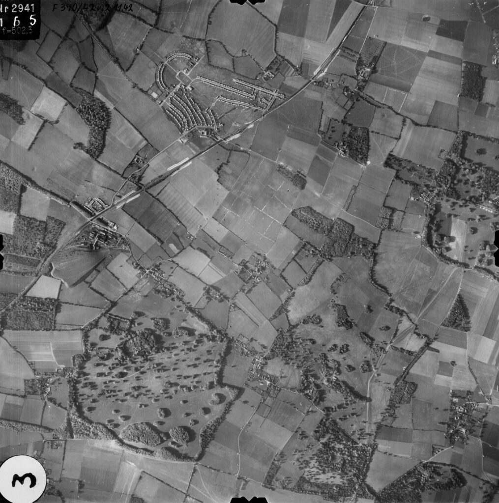
The photographic view below is an overhead view of Fredville Park looking west towards Aylesham and beyond. It was taken by a German Luftwaffe photographic reconnaissance plane on the 2nd September of 1940 during the Battle of Britain.
The newly built mining village of Aylesham, then only some fourteen or so years old, is in the top left corner. The white crosses in the top centre to the west and east of Aylesham [those to the east have Chapman’s Hill to the south, Palm Tree Lane to the west, and Pinner’s Lane to the north] are anti-glider ditches. During the early years of World War 2 poles were erected and ditches were dug as defensive measures in fields thought suitable for landing German troop carrying gliders. My late mother, who lived in Ackholt Road in Aylesham during the 2nd World War, told me that her grand-father was temporarily conscripted to help dig the ditches near Aylesham when he was in his seventies.
Fredville Park is roughly in roughly mid centre near the bottom edge of the photograph with St. Alban’s Court House and Park slightly above off to the right. Goodnestone House Park is in the top right hand corner. Chillenden is approximately a third of the way down the right edge.
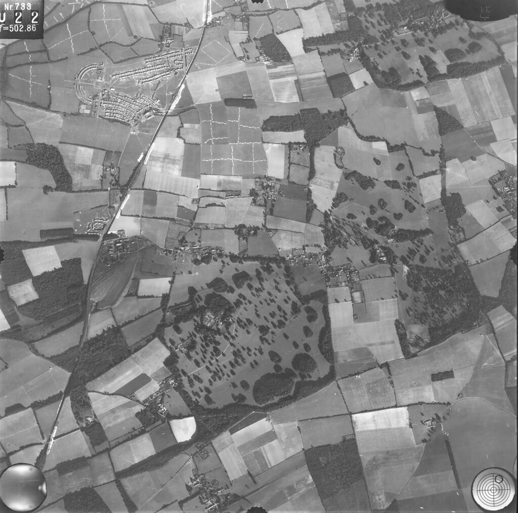
View 1: a photographic view of Nonington from the east looking to the west was taken by a German Luftwaffe photographic reconnaissance plane on the 2nd September of 1940
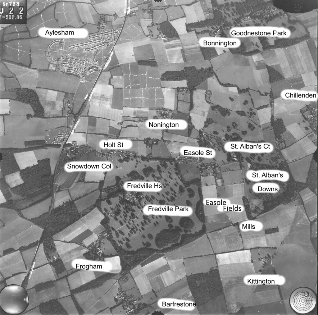
View 2: photographic view of Nonington from the east looking to the west was taken by a German Luftwaffe photographic reconnaissance plane on the 2nd September of 1940 with names of the places referred to in the accompanying text.
Fredville Park and the surrounding area in September of 1940
In late 1939 Fredville Mansion and Park were requisitioned for military use and from early to mid 1940 they were occupied by the Canadian Army, which made Fredville of interest to the German military intelligence services. Along with many other areas of interest the German Luftwaffe overflew Nonington and its environs and took photographs from various heights and directions.
Fredville Park and nearby St. Alban’s Downs housed Canadian armoured units of the 5th Canadian (Armoured) Division.The 5th Canadian (Armoured) Division had left their home country in one main convoy and it landed in the United Kingdom at the end of November of 1941 and dispersed to various locations. A large acreage of the land between Easole Street in Nonington and the edge of Goodnestone Park was brought into use as a tank training area [see view 7 below for more details].
The standard training tanks for Canadian armoured units stationed in the UK were variants of the Canadian designed and manufactured Ram, which was only used for training purposes and never actually went to war as a main battle tank. From 1943 onwards Canadian armoured units destined for service overseas were re-equipped with American Sherman tanks.
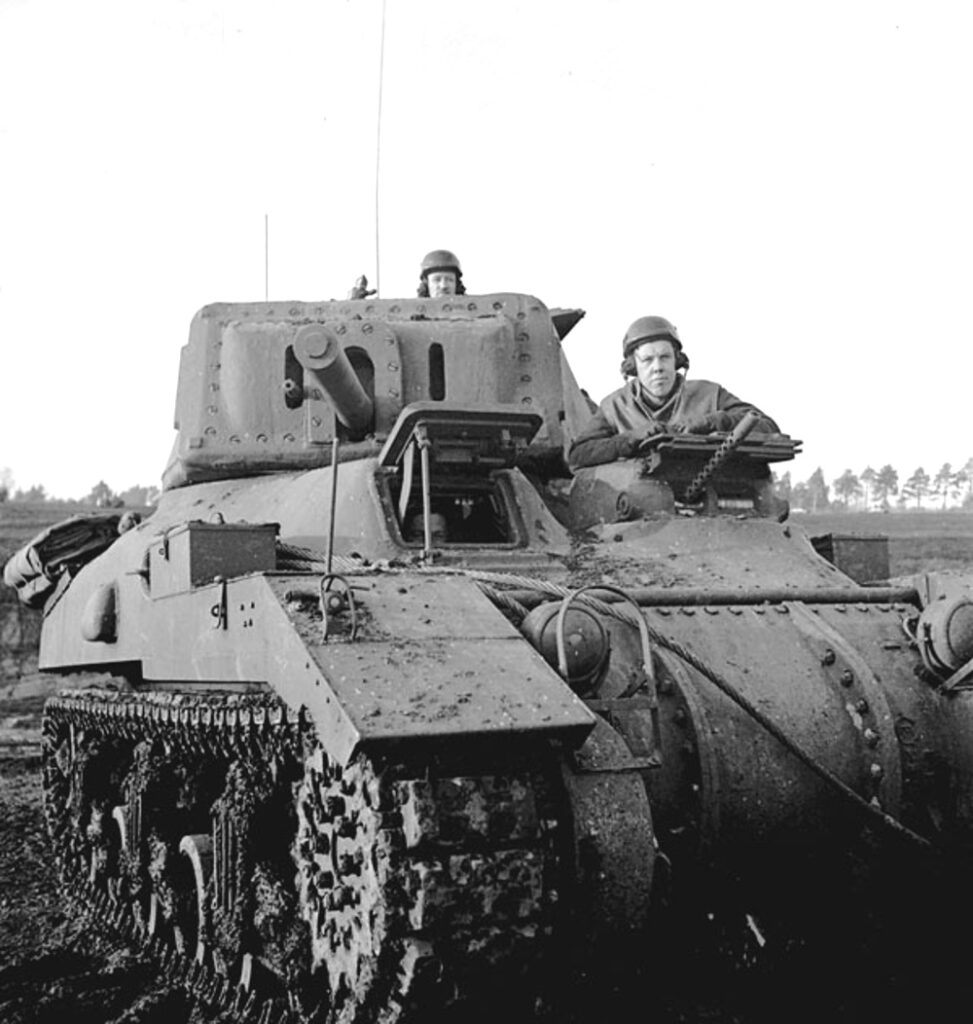
Ram Mk II tank of the Royal Canadian Armoured Corps in England, December 1942 (courtesy of Library and Archives Canada/3587045)
The arrival of tanks into the area had one long lasting benefit, by courtesy of the Royal Engineers, for Nonington and surrounding parishes. After the tanks arrived it was soon noticed that they badly damaged the bends in the road when slewed to maneuver around the corners, so to prevent the roads from becoming impassable to other traffic all of the bends in the roads were dug up and concrete was laid to strengthen the road bed. The Sappers did such a good job that these concreted corners are still serving their intended purpose over eighty years after they were laid. If you look carefully at the corners of the roads in Nonington and surrounding parishes you can clearly see the expansion joints used when the concrete was laid and where the frequently replaced tarmac is worn away the concrete is clearly visible. Even after eighty years or more of ever increasing volumes of traffic and increasingly heavier vehicles these concrete slabs designed and built to carry WW2 tanks show only some minor wear to their surfaces.
Manoeuvring tanks on narrow and winding roads was not easy and damage to adjoining property was a frequent occurrence. Southdown Cottage in Easole Street was hit more than once by a maneuvering tank. I can remember that back in the early 1960’s there were still some roadside telegraph poles scattered around the parish that had chunks taken out them by passing tanks and other military vehicles.
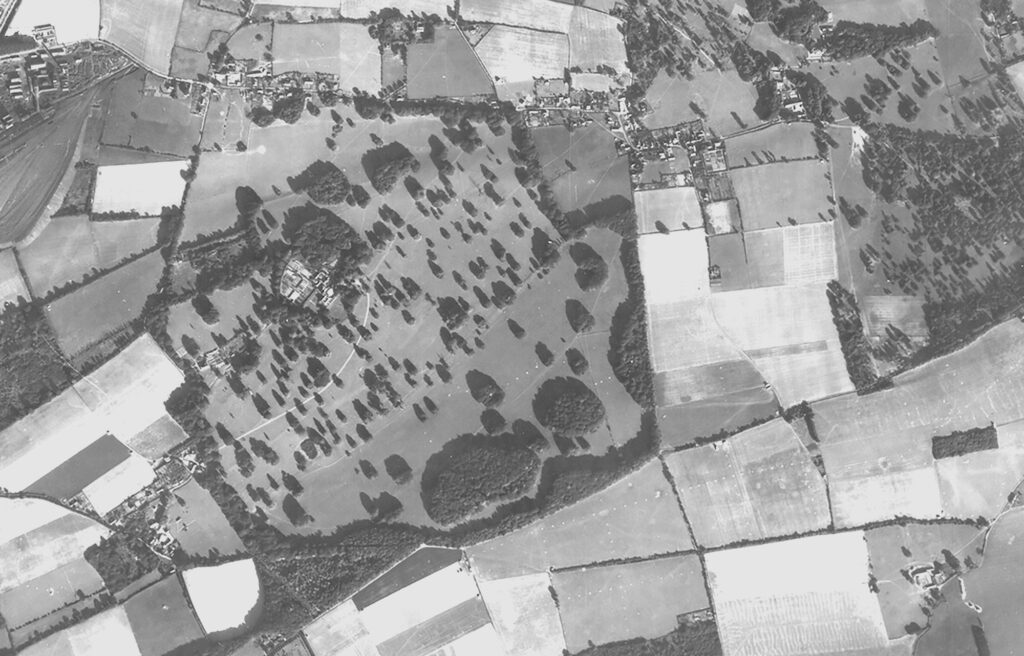
View 3: a crop taken from view 1 of Nonington. In the centre is Fredville Park and House, then recently requisitioned and occupied by Canadian troops. From left to right across the top of the photo:-Snowdown Colliery, Holt St., Easole Street, St. Alban’s Court. Frogham is bottom left, Kittington is bottom right.
View 3, above, is a crop taken from view 1 of Nonington. Snowdown Colliery is in the top left corner. The old Fredville Mansion House complex can clearly be seen in the centre of the park, and in the bottom right hand corner is Kittington Farm. Just above and to the left of Kittington Farm is the triangular area of land occupied by the then standing Easole Corn mill with the adjoining site of the demolished Easole pug mill below. During the 2nd World War the dwelling on the site of the old pug mill was requisitioned for use as an observation post by the Royal Observer Corps, a civil defence organisation intended for the visual detection, identification, tracking and reporting of aircraft over Great Britain.
The lines of white dots in the fields above Kittington and in Easole Fields appear to be chalk from holes dug to receive anti-glider poles. These can be more clearly seen in the photo crop below

View 4: the anti-glider poles near to Kittington
Nonington and the surrounding area in 1942
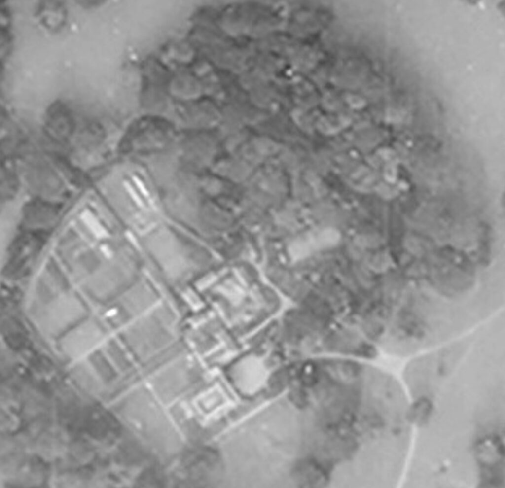
View 5: a photographic view of the Nonington area taken from an easterly direction and centred over Fredville Park was taken by a Luftwaffe photo reconnaissance plane on 2nd November, 1942. Aylesham is at the top of the photo.
The cropped view taken from the above photo of Fredville House and its surrounds [view 6] unsurprisingly shows no really obvious signs of military occupation, but at the time the photograph was taken Canadian troops had been stationed in and around Fredville House for a year or more. Closer inspection of the mansion house reveals that it has no roof, this loss a result of a fire in January of 1941 whilst the house was occupied by the Canadians which so badly damaged the house that it was demolished in 1945.
+++
The Fredville Mansion fire

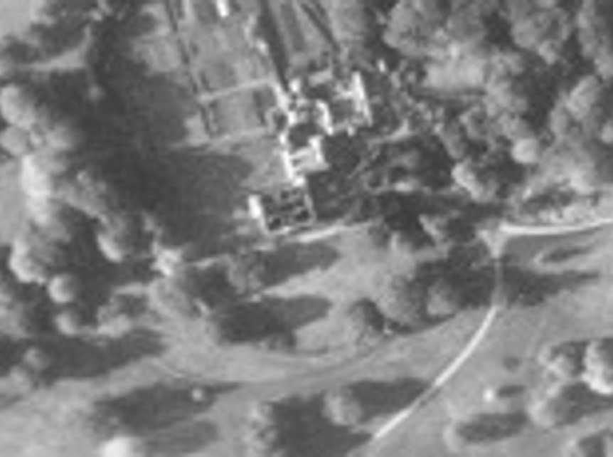
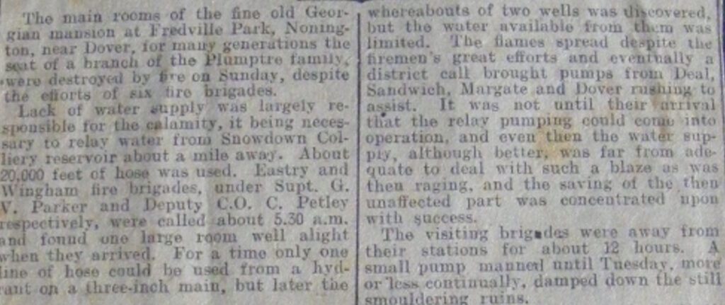
I can remember my late father, who then lived in upper Holt Street next to Holt Street Farm, telling me that the fire fighters called to the conflagration at Fredville Mansion were unable to access enough water close to the mansion to be able to fight the fire effectively. Hoses had to be run across the fields from the nearby Snowdown Colliery to bring in enough water to eventually control the fire. The newspaper clipping below gives a much more detailed account of this.
The house was so badly damaged that it was demolished in 1945.
+++
There are very easily distinguishable remains of the Canadian’s occupation still to be seen. Close by the entrance to the old mansion house site are the well preserved concrete bases of vehicle work shops. Just to the east of the house entrance there is a small semi-circular earth bank which appears to be the remains of a south facing gun pit. This most probably post dates the photo.
There are also the remnants of a line of slit trenches along the southern edge of the Fredville House walled garden that are now largely filled in with leaves and hidden by undergrowth.
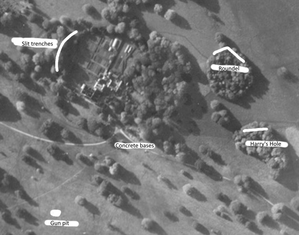
View 6: a crop of Fredville House. Just above the house and surrounding woodland is a clearly visible footpath to the Botany Bank roundel. The wood to the right of the roundel, known as Harry’s Hole, also had slit trenches along the side facing the roundel which were filled in over the decades by leaves and are no longer visible.
Although there are no apparent signs of military occupation to be seen in View 6 , there is one obvious clue. In the field immediately above the house and outbuildings there is a clear footpath leading from the trees surrounding the house to a small roundel know as Botany Bank. Just inside the fence surrounding the roundel on its southern and eastern sides there are the now almost completely filled in remains of several two man slit trenches. These were much more visible when my friends and I used to visit the roundel in the early 1960’s and there were also the remains of barbed wire coils and their metal corkscrew wire pickets to be found. Also the occasional live .303 round and the odd mortar bomb. As late as the 1980’s my late mother found a live incendiary bomb, courtesy of the Luftwaffe, in the wood next to our house in Holt Street, which lays just across the field from the roundel.
There were also some slit trenches along the southern side of Harry’s Hole, an old chalk pit that was once in the open but is now surrounded by a plantation at the top of Hanger’s Hill. However all that is left of these trenches are very slight indentations in the ground which would be easily missed without previous knowledge of their having been there.
Virtually every large beech tree in Fredville Park had initials and full names carved into their bark by soldiers encamped there. In the years after their departure these incised arboreal momentos gradually became indecipherable as the tree bark slowly regenerated but many were still just legible in the late 1960’s and early 1970’s. Sadly, most of these living memorials were blown over during the Great Storm of the 15th-16th of October of 1987, and on those that survived the storm the continuing regeneration of the tree bark has obliteration virtually all traces of those long departed Canadian soldiers handy work.
Footpaths could be a dead giveaway of military positions and were usually either camouflaged or soldiers were made, or at least ordered, to take a more circuitous undercover route to avoid making a discernible path. So to have such an obvious footpath was either a very basic error, or a clever piece of wartime deception.
In the lead up to the Normandy invasions of June 1944 the Allies put into operation “Operation Fortitude South”, the aim of which was to deceive the German High Command into believing that the actual main invasion of France would be made in the Pas-de-Calais region of France, which is directly across the English Channel from East Kent.
It is therefore highly likely that the troops in and around Nonington were part of this deception and that apparent basic military errors, such as leaving obvious footpaths and roadways, were a deliberate ploy to persuade the Germans that there were more troops and equipment in East Kent than were actually there.
View 7 below may also show a further detail of deception in Fredville Park. An obvious footpath can be seen running from the entrance to Fredville House eastwards across the park to a wood, nothing else of a military nature appears to be visible. However, the wood still contains concrete bases, sewer tanks and other parts of the infrastructure for a number of wooden huts which were built there after Fredville’s occupation by the military although little is now visible due to the accumulation of over eighty years of fallen leaves and undergrowth.
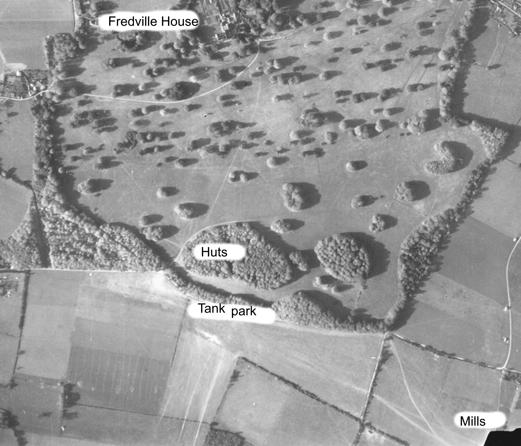
View 7: a crop of the November 1942 Luftwaffe photo showing the location of hut and tanks in Fredville park. The house on the site of the old Easole pug mill was requisitioned for use by the Royal Observer Corps, a civil defence organisation intended for the visual detection, identification, tracking and reporting of aircraft over Great Britain.
A short footpath can also be seen leading from the wood to what appears to be a large tree, and another longer footpath heading of towards the park gate at Frogham. Just below the wood to the east is the shave of trees, called Summer House Plantation, which forms the eastern border of Fredville Park. This strip was the home to a number of tanks.
Decades of leaves and weather have now obscured the concrete road which runs through it and which had tank parking bays running diagonally from it in a herring bone pattern, but it was all very visible when I first remember walking through there with my parents on Sunday afternoon walks in the late 1950’s and early 1960’s.
There are also other footpaths in the bottom right hand corner of the photo apparently leading to Kittington Farm, which is just off of the edge of the photo. It is also noticeable that the holes dug for the anti-glider poles which were so obvious in the 1940 photo have either blended in with the soil or the poles had been removed and the holes filled in, possibly to make easier to farm the land.
A similar possibly deception also seems to have been in play on and around St. Alban’s Downs where more troops and vehicles were stationed.

The St. Alban’s Down area.
The entrance to a WW2 concrete tank road is still to be seen on Sandwich Road just before the turning into Grannies Lane. On the opposite side of the road to the tank road entrance, View 8 shows an unsurfaced road running roughly in parallel with Cherry Garden Lane that ends near Bonnington Farm. Most of the land between Easole Street and Goodnestone was commandeered by the military for use as a tank training ground, but other than assorted track marks there is little evidence of tanks or other vehicles to be seen on the photos. Very good camouflage, or deception?
I have been reliably informed that the tanks left at sometime in 1943, which would coincide with 1 Canadian Corps, of which the 5th Canadian (Armoured) Division was a part, being sent to take part in the Italian Campaign in November of 1943.
Mill Top Road runs along the eastern edge of St. Alban’s Downs and in the shave on the eastern side of the road is a line of over a dozen slits trenches cut into the bank. These were all open in the late 1950’s and early 1960’s when I used to regularly examine for munitions and other military detritus during Sunday afternoon walks with the family, but even then they were gradually filling up with leaves and debris and they are now difficult to see.
++++++++++++
More original Luftwaffe aerial photographs with accompanying annotations can be seen at
A Luftwaffe view of Nonington in 1940 & 1942
++++++++++++
For further information on Nonington in World War Two and other wars, please go to Nonington in the wars

