
The name Essole or Esole Street, now Easole Street, refers to the original settlement or Vill’ of Essole, not the roadway. Ancient strip settlements with house plots on either side of a road or track way were called “street”. Holt Street and Frogham Street are also very good examples of a strip or “street” settlement.
The vill’ was the smallest territorial and administrative unit and continued as such after the Norman conquest and into the late Medieval era. The vill’ had judicial and policing functions, including frankenpledge, as well as responsibility for taxation, roads and bridges.
The rental rolls full descriptive title is:
“Essole. This is the rental there of the Lord Abbot and Convent of St. Alban of all the rents due and payable at the feast of St. Michael the Archangel [Michaelmas Day, 29th September]. And the tenants there bound to serve the Court from three weeks to three weeks and to pay suit of Court.
Rental there renewed in the year 1501 and in the 16th year of the reign of King Henry VII for Thomas Derbi, Robert Kockesale, Richard Walsche, Stephen Creke, John Walsche, Simon Quilter and Thomas Webbe holding the same”.
Suit of court was the obligation to attend the manorial court baron and non-attendance resulted in a fine to the defaulter. Wealthy large or absentee land holders would have sent a representative in their stead. The court baron was the principal type of manorial court and administered the customs and laws of the manor and dealt with and punished any infringements of them, usually by issuing a fine which went to the lord or lady of the manor. A court baron would typically have been held every three or four weeks, although for some manors the time between courts could have been much longer.
The Convent and Abbey of St. Alban’s had been given the adjoining Manor of Eswalt around 1100 and had acquired the Manor of Essole in the early 1300’s. The rentals were manorial dues owed to the Abbot, as lord of the manor, by the owners of free hold land and property within the Manor of Essole [also Esole]. The 1501 rental roll records that the Abbey received an annual fixed payment of 1 shilling [5 pence] per acre for prime arable or grazing land.
Land owned by the Abbey itself, known as demesne land, was not liable for manorial fees as this would would have meant that the Abbey was paying the money to itself. The two small pieces of land owed by the Abbey shown on the map below are only identifiable because they are referred to as bordering land or property that was liable for rental payments. Southdown Cottage does not appear in the rental roll, the most likely explanation for this omission is that the house and any attached land was by then owned by the Abbey.
~~~
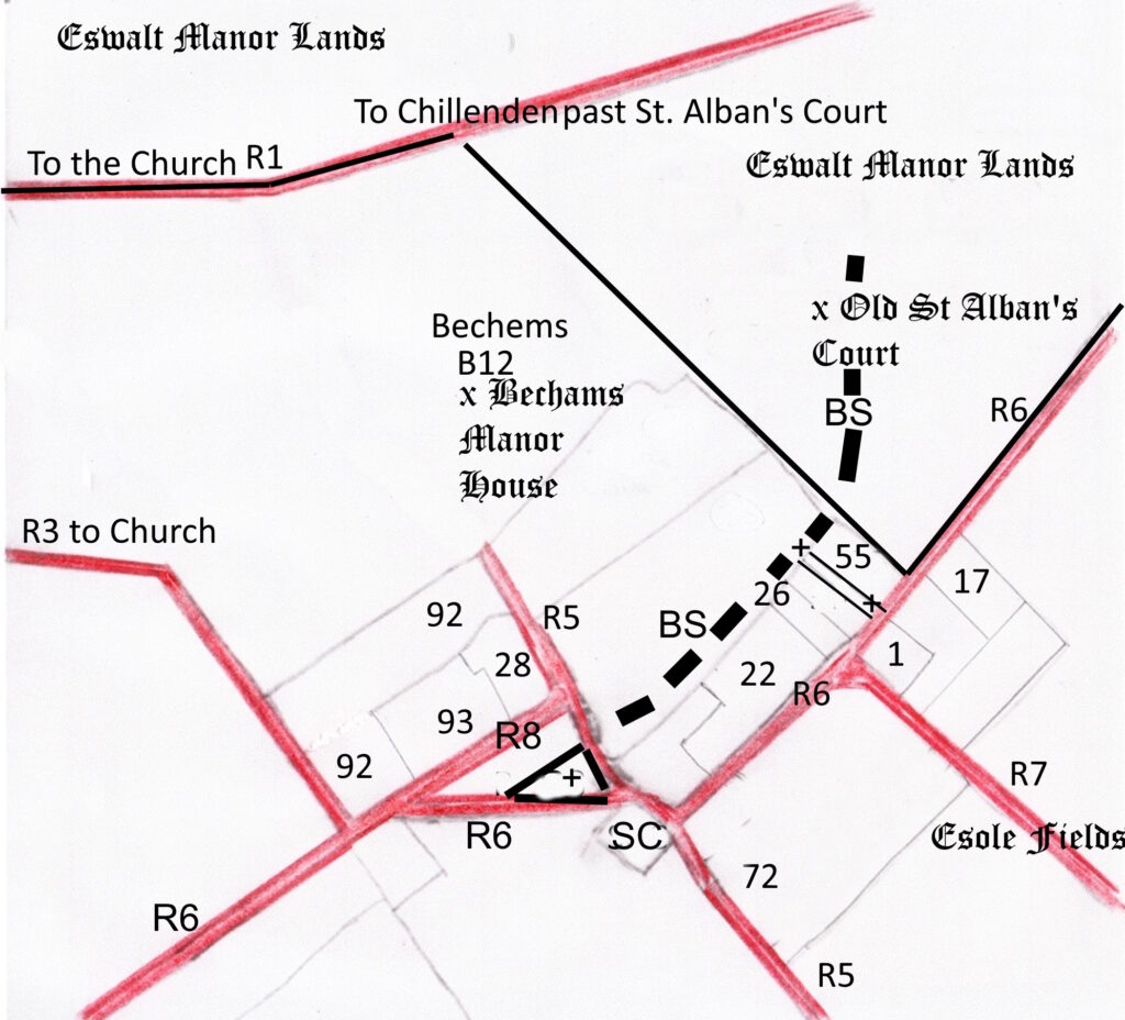
The map below identifies those individual messuages, dwelling houses with outbuildings and land assigned to their use, referred to in the 1501 rental roll which were liable to pay rentals.
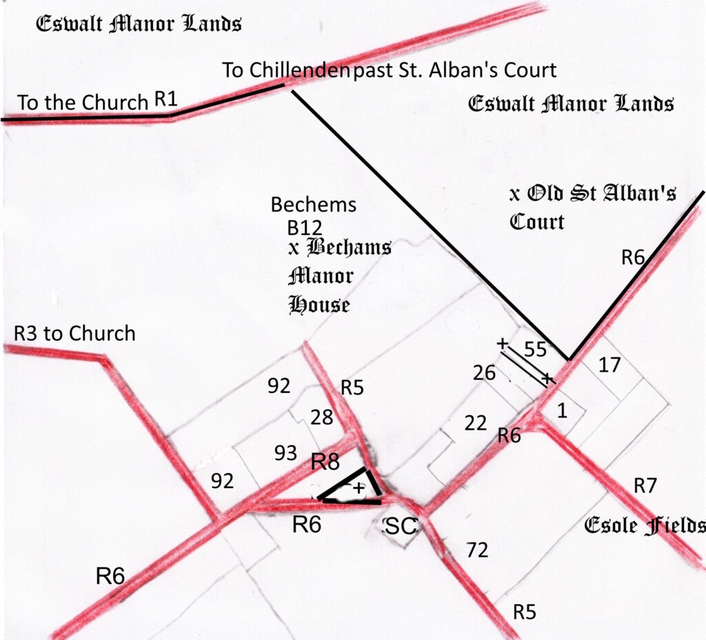
Essole house plots & road ways in 1501. The location of the houses and road ways in medieval Essole have been gleaned from the Abbey of St. Alban’s manorial rental roll for the Manor of Essole for 1501. The sketch map outlining the house plots and routes of the road ways was taken from the 1859 Poor Law Commissioners map of Nonington, the plots being virtually identical some 350 plus years after the manorial roll was written. Some of the house plots house plots are still readily identifiable, as are the road ways.
Key to the above map
Land identified as being owned by the Abbey:-
+—+ Strip of land owned by the Abbey of St. Alban’s between plots 26 & 55. There also appears to be a small and apparently triangular piece of Abbey owned land in front of plots 28 & 93 between R6 and R8.
SC is Southdown Cottage, which is omitted from the rental roll and therefore have been owned by the Abbey. Alternatively, it could be the messuage recorded as having previously been in the possession of Robert Kocsale but at the time the roll taken in 1501 had come into the possession of Stephen Bayle. [See item 92 below].
~~~
The free hold house plots identifiable
in the 1501 rolls
NB:- there are four roods in an acre and a hundred and sixty perches make up the same.
B12-William Boys, Bechams, a messuage and forstal. The Bechams house and lands amounted to fifty acres and two roods, for which William Boys paid the Abbey the sum total of
£.2 2s 9d [£2 14 pence]. This site has been under archaeological investigation for the last twenty years or so and the remains of a series of manor houses and ancillary buildings have been revealed. A forstal was an area of land in front of a large house or the way leading to it. Forstal is still a very common field, wood and place name in Kent.
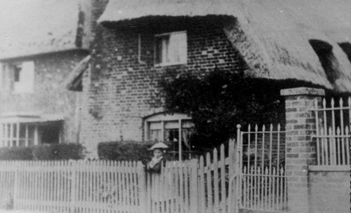
1-Thomas Derbi. East Stoole Farm-the thatched cottage at the north side at the bottom of Mill Lane. The roll records “Thomas Derbi holds half an acre of land in his messuage“.
[[1-there is a note in margins of the original document:-“now John Walsche”].
17- Richard Welsche. On the site of the 1704 malthouse. The roll records “The same Richard holds in his messuage 1 acre and 1 rood of land“.
22- Stephen Kreke [also Creke, Creake]. The present Old House in Easole Street opposite the bottom of Mill Lane. The roll records “The same Stephen holds one messuage containing 3 roods of land“.
26- John Walsche . On the site of the present Limes House opposite the bottom of Mill Lane. The roll records “John Walshe holds half an acre of land in his messuage”.
28- Heirs of John Castell. The construction of the present White House Farm, the building of the house was quite possibly begun by John Castell. The roll records “The heirs of John Castell hold half an acre in their messuage”.
55- Thomas Webbe. On the site of present Home Farm House. The roll records “Thomas Webbe holds in his messuage half an acre of land”.
72- Richard Chamberlayne. Richard may quite possibly have actually lived in the still standing thatched cottage on the north side of Butcher’s Alley. The roll records ” The same Richard holds 2 acres and 3 roods and 17 perches of land with his messuage and 2 crofts” and it extended from Butcher’s Alley to Mill Lane and down the slope to Easole Street.
92- Robert Kocsale, also Coksall, Coksalle, Koksall & Koxsall. On the site of the brick farmhouse opposite the Baptist Chapel in Easole Street. The roll records “The same Robert holds in his messuage 3 acres of land”.
However, there is a another entry on the roll that records: “that Robert Coksall had 24 acres with 7 roods ………. that now left out of the rentall the whiche messuage Stephen Bayle hath so that Stephyn Bayle hath of lands …. sometime Coksalles 18 acres half rood”.
This appears to show that Robert Kocsale, ect., had disposed of 18 or so acres of land and a house to Stephan Bayle. The location of the house is not readily identifiable, but one possibility is that it was the present Southdown Cottage.
93- Simon Quylter. The old thatched cottage know as Shakespeare Cottage which stood opposite the Baptist Chapel and was demolished in the 1970’s. The roll recorded that “Simon Quylter holds one messuage with 1 acre of land and 16 perches of land in the Villata of Essole”.
~~~


~~~
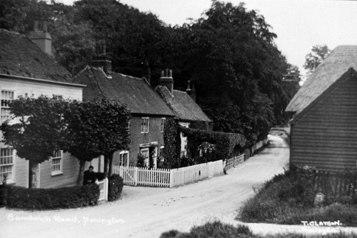
More old photographs of Easole Street can be found in the
Easole Street picture gallery
~~~
Various roads and ways
R1-the road to the left from the present Beauchamps Corner goes to St. Mary’s Church, to the right was an ancient road way past St. Alban’s House to Chillenden and Rowling and beyond to Eastry and Sandwich. Referred to in the rental roll as “le Churcheway” as in a south-westerly direction it led to the church. There is also another church way referred to in the rental roll text, see R3 below. In documents of this period any road way or path within the parish that led to St. Mary’s Church was referred to as a church way.
R3-also referred to as “le Churcheway”, this is now the footpath [EE 313] running from opposite the Baptist Chapel in Easole Street to the Church Street cross-roads.
R5-referred to as “le Schereway”, it forms the southern boundary of the Esole Fields. This southern boundary is now known as Butcher’s Alley or Butcher’s Lane [footpath EE 317]. The Esole Fields are divided into two parts by “the common way” to Kittington, now known as Mill Lane.
A sheer way, shereway, or shire way was Kent dialect for a track or road that was not a king’s highway but was in general use but ran through private land i.e. a park. In Kent dialect “e” or “ee” was pronounced as an “i”, as in ship or tip. There were strict laws and restrictions regarding the king’s highways that did not apply to shereways.
R5 is recorded as “le Schereway” until it reaches White House Farm where it is then referred to as “the Common Way”. There is no reference to it beyond this point, which indicates that most of the length of the present Beauchamps Lane was used mainly to access the Bechams manor house. At the time of the 1501 manorial roll the route of “le Schereway” took it through what later became the farm yard for White House Farm. It was later diverted to its present route on the southern edge of the old farmyard and became part of the present Easole Street road past the Village Hall.
In it’s entirety this shereway runs almost in a straight line from Tye Wood to the Bechams manor house, a distance of a mile or so. Tye is derived from the Old English teag, meaning a small enclosure. In Kent, from as early as the 13th century, it came to mean a common pasture. The shereway most likely began life as a cattle or sheep road, the 1501 rental roll records that as part of the Bechams lands John Boys had a two acre and a four acre pieces at “Le Tye”.
R6-the King’s Way or the King’s Street, now known as Easole Street. Part of what was then the King’s Way is now the footpath [EE 316a] that runs from the side of the Baptist Chapel to the eastern side of the Village Hall. Originally this part of the King’s Way and later a footpath ran diagonally across the site of the bungalow next to the Village Hall to the the corner of Southdown Cottage to form a cross-roads with “le Schereway” [see R5 above].
R7-the common way to Kittington, now Mill Lane and the footpath [EE 321] from the top of Mill Lane past the old mills sites and on to Kittington .
R8-the short section of road, referred to as the common way to the west, joining le Shereway to the King’s Way in front the gates of the messuage of Heirs of John Castell, plot 28.
BS-in mid-14th century Esole manor rentals there are references to a Bakke or Backe Street in Esole, which I believe was so named as it ran along the back of the house plots on the west side of the King’s Street. Although it is not mentioned in the 1501 rental rolls this “street” it must have still been in use, possibly as rear access to the house plots, and it is still in use to this day as a foot path [EE 311].
~~~
For further information on footpaths in and around Nonington please go to
KCC Rights of Way Map
~~~
