
The present village of Aylesham was built on land was once a hunting park for the Archbishops of Canterbury. The village was established in 1926 and designed and built by Dorman, Long & Co. to house the workers at the company’s nearby Snowdown Colliery who came from all parts of the UK seeking better wages and safer conditions. The history of Aylesham has been very well recorded is readily available on the internet on sites such as the Aylesham Heritage Centre.
Although the village of Aylesham is only a hundred years or so old the name Aylesham has its origins far into the past.
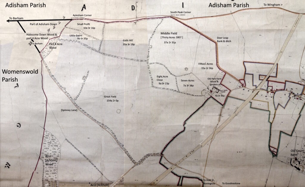
The 1859 Poor Law Commissioners map for the Parish of Nonington showing the area from the Halesome [Aylesham] Wood, in the top left of the map above, to Ratling and Old Court Farm. In between is the area occupied by Curleswood Park. The names are contemporary to the surveying of the map in 1859 with the exception of Spinney Lane, which was then a roadway maintained by the Parish of Nonington as part of “the road from Aylesham Wood to Goodestone Corner”. The name Aylesham Corner features on the 1859 and later Ordnance Survey maps. Along with South Peak Corner it appears have been used as a boundary marker for the Curleswood Park estate.
The name is said to derive from the Old English Aegeles ham; meaning the homestead or farm of Aegel or Ægel [with the g pronounced like the y in yes], which over the centuries evolved via Elisham [1367]; Eylsham [1405]; Aylsham [1418]; and Haylesham [1445] to its modern spelling of Aylesham by 1604.
The village of Aylsham in Norfolk is said to have a similar origin to its name.
There is a Halesome Down Wood up in the top left corner, this would appear to be a phonetic spelling based on an enquiry to a local inhabitant as to the name of the wood. This may have been the result a either a mis-hearing of Aylesham being said as “Aylsum” or of Adisham as “Adsum”.
It was common in the local East Kent dialect, now sadly seldom heard or spoken, to pronounce the “sh” sound as an “s”. Hasted, in hist history of Kent written at the end of the 18th century, records that Adisham was commonly pronounced as “Adsum”, so presumably the “sh” in Aylesham would have been similarly mis-pronounced by local inhabitants. The wood is adjacent to a piece of arable land that was recorded as being a part of Adisham Down in the 1839 Nonington and Womenswold parishes tithe apportionments.
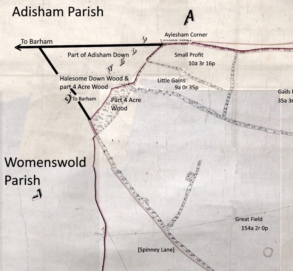
Halesome Down Wood appears to be a phonetic spelling based on an enquiry to a local inhabitant as to the name of the wood. This may have been the result a either a mis-hearing of Aylesham being said as “Aylsum” or of Adisham as “Adsum”.
It was common in the local East Kent dialect, now sadly seldom heard or spoken, to pronounce the “sh” sound as an “s”. Hasted, in hist history of Kent written at the end of the 18th century, records that Adisham was commonly pronounced as “Adsum”, so presumably the “sh” in Aylesham would have been similarly mis-pronounced by local inhabitants. The wood is adjacent to a piece of arable land that was recorded as being a part of Adisham Down in the 1839 Nonington and Womenswold parishes tithe apportionments.
The word “Well” is written can be seen in the top left corner of the 1859 map above and appears to be the name of the triangular area created by the south west boundary of Old Park Farm with Spinney Lane to the south and the Wingham road, now the B2046, to the west.
On the 1859 maps above Well is divided between woodland on the southern side and arable land, recorded as being part of Adisham Down, on the western side.
Weald, sometimes written as wald in some dialects, was Old English for woodland or forest and in this case appears to have evolved into welle by the 14th century and well by 19th century, as is shown on the maps above. This indicates that this was an ancient woodland area, almost certainly a part of the ‘Crudes silva’, meaning Crudes Wood referred to in the charter for a land grant made by King Alfred of Wessex of 873.
Well Wood in neighbouring Womenswold parish is a quarter of a mile or so across the fields to the south. Womenswold has had many different spellings of its name over the centuries. The first presently known reference to Womenswold is as “Wimlincga Wald” in a charter recording an exchange of land at nearby Barham of Archbishop Wulfred of Canterbury of 824 where the Wald element means woodland, or possibly woodland pasture for swine.
The earliest presently known reference to Aylesham Wood, and also Welle or Well, is in a 1367 grant from “Thomas Peny of Welle to Salomon Oxene (of Oxenden, a half a mile to the east) of 20s being the rent of a wood ect. at Elisham juxte Crudeswode (next to Crudeswode, later Curleswood Park) in Welle”.
The woodland is referred to again in 1405 in a grant from “Matilda, widow of John Twytham, to Henry Danyel, of five pods of wood in a wood called Eylsham abutting on the park called Cuddeswode (Curleswood)”.
A pod was probably equivalent to a cant, which is a block of woodland coppiced (harvested) on a regular basis. Woodland was economically very important in medieval Kent as it provided everything from building materials to fuel for cooking and industry.
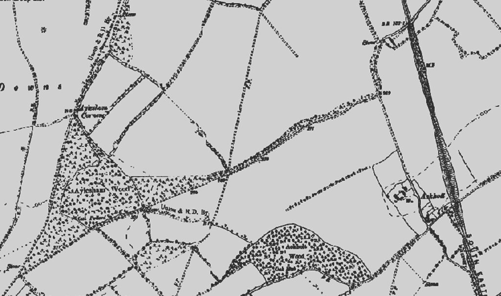
Above:-Aylesham Wood in the 1870′s, an extract from the Ordnance Survey map. The main difference to the 1859 map is that the original woodland and new growth trees now cover the whole area. The field boundaries are unchanged and still easily recognizable.
A few years later in 1418 a grant was made by Henry Danyel of Sellynge (Selling, near Faversham), to John Fyneux, Thomas Marchaunt and John Tooks of “lands in Aylsham including Croddyswood (Curleswood)”, and in 1445 a release was made by John Monyn and John Holte to Richard Sandys , Esq., and John Greneford “of the Manor of Acholt, with lands ect., at Haylesham Nonyngton, and Wemynlyngs Welde (Womenswold) near Wingham”.
Some 160 years later in 1604 “John Swanton of Aylesham [in Nonington], yeoman”, was elected as the Nonington parish constable, an important position in the community as he would have been responsible for upholding the law and apprehending lawbreakers within the parish and was answerable to the local magistrates. His description of “yeoman” and his election as constable indicates he was a well-to-do farmer, either owning at least some of his own land, or renting a fairly substantial farm. Parish constables were eventually replaced by the fore runner of the modern police in the early 1800’s.
There is no known reference to the location of any dwelling in or near to Aylesham Wood, so where “John Swanton of Aylesham [in Nonington], yeoman” actually lived is not clear. The farm house and accompanying buildings may now lay underneath the trees in the present Aylesham Wood, or its possible that his farm may have actually been located at the southern end of the present Ackholt Wood.
The 1839 Nonington parish tithe map has an Ackholt Wood House and some three and a half acres of land at the southern end of Ackholt Wood listed as belonging to Sir Brook William Bridges and occupied by William Gilham, but there is no record of the house or land on the 1859 parish tithe map. The location is now overgrown, but still discernible as the trees there are not as high or as mature as the rest of the wood.

Since the time of John Swanton history appears to have passed Aylesham by. The original Aylesham area is still all woodland, but is now protected. Hopefully it will remain this way. Sadly, since the first houses for the colliery workers were built in the 1920’s the adjoining Park Farm has now disappeared underneath housing and business and industrial premises.
I’m glad you found it interesting, Chris.
Really interesting- thank you
I’m glad you liked it, Paul
Thanks for sharing this.